Phone: +88 017 06611166 Email: info@surveyinstrumentbd.com
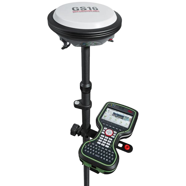
LEICA RTK GPS GS16
Features
Engaging software
The Leica Viva GS16 GNSS smart antenna is accompanied with the revolutionary Captivate software, turning complex data into the most realistic and workable 3D models. With easy-to-use apps and familiar touch technology, all forms of measured and design data can be viewed in all dimensions. Leica Captivate spans industries and applications with little more than a simple swipe, regardless of whether you work with GNSS, total stations or both.
Infinitely bridging the field to the office
Leica Infinity imports and combines data from your GNSS, total station and level instruments for one final and accurate result. Processing has never been made easier when all your instruments work in tandem to produce precise and actionable information.
SKU: RTK GPS
Category: RTK GPS, Leica RTK GPS
Product Details
| GNSS TECHNOLOGY | ||
| Self-learning GNSS | Leica RTKplus SmartLink (worldwide correction service), SmartLink fill (worldwide correction service) | Adaptive on-the-fly satellite selection, Remote precise point positioning (3 cm 2D), Initial convergence to full accuracy typically 18 min, Re-convergence < 1 min Bridging of RTK outages up to 10 min (3 cm 2D) |
| Leica SmartCheck | Continuous check of RTK solution | Reliability 99.99% |
| Signal tracking | GPS (L1, L2, L2C, L5), Glonass (L1, L2, L2C, L32), BeiDou (B1, B2, B32), Galileo (E1, E5a, E5b, Alt-BOC, E62), QZSS (L1, L2C, L5, L62), NavIC L53, SBAS (WAAS, EGNOS, MSAS, GAGAN), L-band | |
| Number of channels | 555 (more signals, fast acquisition, high sensitivity) | |
| MEASUREMENT PERFORMANCE & ACCURACY | ||
| Time for initialisation | Typically 4 s | |
| Real-time kinematic (Compliant to ISO17123-8 standard) | Single baseline Network RTK | Hz 8 mm + 1 ppm / V 15 mm + 1 ppm, Hz 8 mm + 0.5 ppm / V 15 mm + 0.5 ppm |
| Post processing | Static (phase) with long observations, Static and rapid static (phase) | Hz 3 mm + 0.1 ppm / V 3.5 mm + 0.4 ppm, Hz 3 mm + 0.5 ppm / V 5 mm + 0.5 ppm |
| Code differential | DGPS / RTCM | Typically 25 cm |
| COMMUNICATIONS | ||
| Communication ports | Lemo, Bluetooth | USB and RS232 serial, Bluetooth® v2.00 + EDR, class 2 |
| Communication protocols | RTK data protocols, NMEA output, Network RTK | Leica, Leica 4G, CMR, CMR+, RTCM 2.2, 2.3, 3.0, 3.1, 3.2 MSM & NMEA 0183 V 4.00 and Leica proprietary & VRS, FKP, iMAX, MAC (RTCM SC 104) |
| Built-in data links | 3.75G GSM / UMTS / CDMA phone modem, Radio modem | Fully integrated, internal antenna, Fully integrated, receive and transmit, external antenna 403 - 473 MHz, 1 W output power, up to 28800 bps over air or 902-928 MHz (licence free in North America); up to 1.0 W output power |
| External data links | GSM / GPRS / UMTS / CDMA and UHF / VHF modem | |
| GENERAL | ||
| Field controller and software | Leica Captivate software | Leica CS20 field controller, Leica CS35 tablet |
| User interface | Buttons and LEDs, Web server | On / Off and Function button, 7 status LEDs, Full status information and configuration options |
| Data recording | Storage, Data type and recording rate | Removable microSD card, 8 GB, Leica GNSS raw data and RINEX data at up to 20 Hz |
| Power management | Internal power supply, External power supply, Operation time | Exchangeable Li-Ion battery (2.6 Ah / 7.4 V), Nominal 12 V DC, range 10.5 - 28 V DC, 7 h receiving (Rx) data with internal radio, 5 h transmitting (Tx) data with internal radio, 6 h Rx / Tx data with internal phone modem |
| Weight and dimensions | Weight Diameter x Height | 0.93 kg / 3.20 kg standard RTK rover setup on pole 190 mm x 90 mm |
| Environmental | Temperature, Drop, Proof against water, sand and dust, Vibration, Humidity, Functional shock | -40 to 65°C operating, -40 to 80°C storage, Withstands topple over from a 2 m survey pole onto hard surfaces, IP68 (IEC60529 / MIL STD 810G 506.5 I / MIL STD 810G 510.5 I / MIL STD 810G 512.5 I), Withstands strong vibration (ISO9022-36-08 / MIL STD 810G 514.6 Cat.24), 100% (ISO9022-13-06 / ISO9022-12-04 / MIL STD 810G 507.5 I), 40 g / 15 to 23 msec (MIL STD 810G 516.6 I) |
More Information