Phone: +88 017 06611166 Email: info@surveyinstrumentbd.com
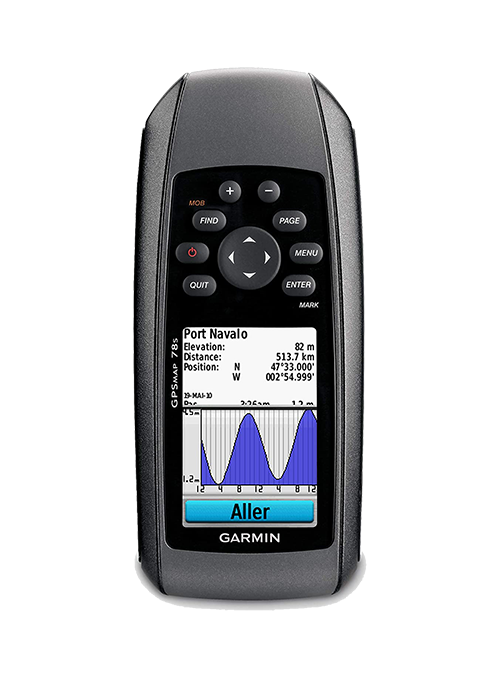
GARMIN GPS MAP 78s
Features
For boaters and watersports enthusiasts who want to run with the best, the rugged GPSMAP 78s features a 3-axis compass, barometric altimeter, crisp color mapping, high-sensitivity receiver, new molded rubber side grips, plus a microSD™ card slot for loading additional maps. And it floats!
Explore
GPSMAP 78s comes with built-in worldwide basemap, so you can navigate anywhere with ease. And, like the rest of the 78-series, 78s is water resistant (IPX7) and even floats in water.
Get Your Bearings
GPSMAP 78s has a built-in 3-axis tilt-compensated electronic compass, which shows your heading even when you’re standing still, without holding it level. Its barometric altimeter tracks changes in pressure to pinpoint your precise altitude, and you can even use it to plot barometric pressure over time, which can help you keep an eye on changing weather conditions.
Share Wirelessly
With GPSMAP 78s you can share your waypoints, tracks, routes and geocaches wirelessly other compatible device users. Now you can send the location of your favorite fishing spot to a friend to find. Sharing data is easy. Just press “send” to transfer your information to similar units.
Keep Your Fix
With its high-sensitivity, WAAS-enabled GPS receiver and HotFix™ satellite prediction, GPSMAP 78s locates your position quickly and precisely and maintains its GPS location even in heavy cover and deep canyons. The advantage is clear — whether you’re in deep woods or just near tall buildings and trees, you can count on GPSMAP 78s to help you find your way when you need it the most.
SKU: GPS
Category: Global Positioning System (GPS), Garmin Handheld GPS
Product Details
General
| Physical dimensions | 2.6" x 6.0" x 1.2" (6.6 x 15.2 x 3.0 cm) |
| Display size | 1.43" x 2.15" (3.6 x 5.5 cm); 2.6" diag (6.6 cm) |
| Display resolution | 160 x 240 pixels |
| Display type | Transflective, 65-K color TFT |
| Weight | 7.7 oz (218.3 g) with batteries |
| Battery type | 2 AA batteries (not included); NiMH or Lithium recommended |
| Battery life | 20 hours |
| Water rating | IPX7 |
| High-sensitivity receiver | Yes |
| Memory/History | 1.7 GB |
Maps & Memory
| Ability to add maps | Yes |
| Basemap | Yes |
| Automatic routing (turn by turn routing on roads) for outdoor activities | Yes (with optional mapping for detailed roads) |
| External memory storage | microSD™ card (not included) |
| Waypoints/favorites/locations | 2000 |
| Track log | 10,000 points, 200 saved tracks |
| Routes | 200 |
Sensors
| Barometric altimeter | Yes |
| Compass | Yes (tilt-compensated 3-axis) |
Outdoor Recreation
| Area calculation | Yes |
| Hunt/fish calendar | Yes |
| Sun and moon information | Yes |
| Geocaching-friendly | Yes (Paperless) |
| Custom maps compatible | Yes |
| Picture viewer | Yes |
More Information